SIGMET/AIRMETs Help Page 2 of 2
The SIGMET/AIRMETs in the graphical image have the following representation.
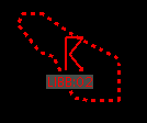
- An icon (see the table below) is placed approximately in the center of the SIGMET/AIRMET polygon.
Icon Description 
Tropical cyclone 
TC forecast 
TC outlook 
Thunderstorms 
Hail 
Squall line 
Moderate turbulence 
Severe turbulence 
Moderate icing 
Severe icing 
Volcanic ash 
VA forecast 
VA outlook 
Limited visibility 
Mountain obscuration 
Cloud 
Mountain wave 
Sand/Dust storm 
Unknown weather type - The SIGMET/AIRMET issuing FIR and ID are placed under the icon. In this example,
"RKRR" is the FIR and "01" is the ID.

- A polygon is drawn around the SIGMET/AIRMET area:
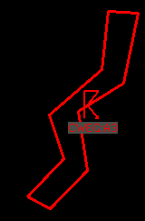
Note that if the SIGMET/AIRMET boundaries cannot be decoded from the SIGMET/AIRMET text but the FIR for the SIGMET/AIRMET can be decoded, the polygon is drawn around the entire FIR even if the SIGMET/AIRMET only includes a portion of the FIR. The polygon around the FIR will have dashed, rather than solid, edges. See the text for the SIGMET/AIRMET to determine its actual location.
Return to SIGMET/AIRMETs Page or GO Back 1 page